

Visits to Research Infrastructures
The National Institute of Oceanography and Applied Geophysics – OGS

OGS is a public research institution which operates internationally in the field of physical, chemical, biological and geological oceanography, experimental and exploration geophysics, seismology and engineering seismology. OGS has research facilities in three locations in the surroundings of Trieste: Borgo Grotta Gigante (headquarters), Miramare and Santa Croce.
Among its many sites and research infrastructures, in the scope of BSBF 2024 OGS has selected the following facilities:
A) OCEANOGRAPHIC INFRASTRUCTURES
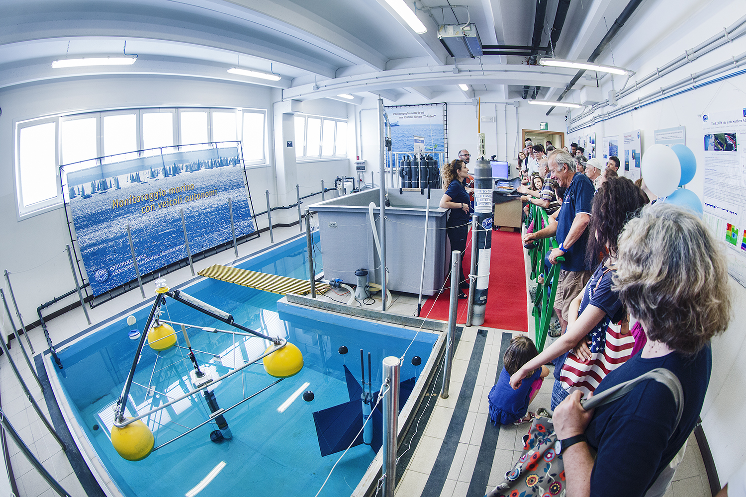
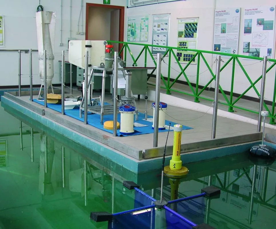
Testing Tank
The Testing tank is an infrastructure whose function is to provide all the test operations preceding the installation in situ of oceanographic instrumentation, which is normally used in measurement campaigns or fixed observation sites. The Testing tank is a laboratory for testing oceanographic instrumentation, which is used in measurement campaigns or fixed observation sites. It is also used for testing prototypes that are developed in the laboratories of the OGS Oceanography Section. It consists of two tanks, both equipped with a filtering system, a larger one (L-shaped; maximum length 9.9 m; maximum width 3.6 m; depth 1.4 m) filled with fresh water and a smaller one (2 m x 1.5 m x 0.9 m) filled with sea water. The latter is used in particular for balancing Slocum gliders before launching them. The laboratory is also equipped with a small bridge crane for handling the instruments with a load capacity of up to 200 kg.
B) SEISMOLOGICAL INFRASTRUCTURES
B1) REAL TIME SEISMOLOGY SERVICE (RTS-CRS)
The Real Time Seismology Service (RTS-CRS) monitors seismicity in North-eastern Italy, with seismic alert purposes for the Civil Protection of the Friuli Venezia Giulia and Veneto Regions.
For seismic events that may be significant for the population, an alert message is automatically sent, within 2-5 minutes from the event, to the competent authorities (via fax, email and sms).
All seismic events, automatically located and subsequently reviewed by the operator, are published in real time on the RTS website.
Event notifications are also published on the institutional social channels Facebook and Twitter.
B2) SEISMIC MONITORING OF INDUSTRIAL ACTIVITIES
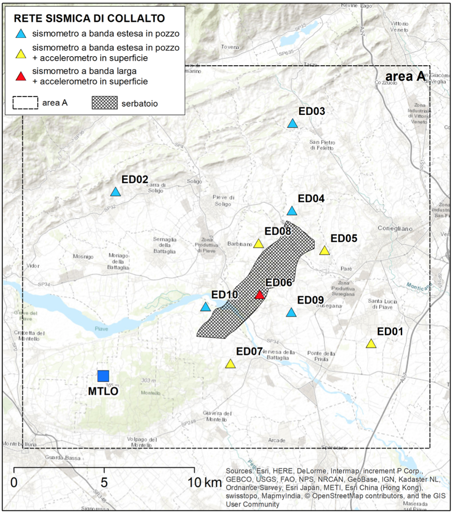
– Collalto Seismic Network (RSC) OGS manages the Collalto Seismic Network (RSC) for seismic monitoring in the natural gas storage concession area called Collalto Stoccaggio (TV), managed by Edison Stoccaggio S.p.A. Given the medium-high seismic hazard of the area, the network was designed to detect both local micro-seismicity and natural seismicity in the area surrounding the reservoir. The network (operational since 2012) is the first public network built in Italy following ministerial requirements for seismic monitoring of gas storage activities, and consists of ten broadband seismometric stations and a permanent GNSS geodetic station. All seismometers are installed in the well, while accelerometers are installed on the surface.
– Cornegliano Laudense Seismic Network (RSCL) OGS also manages the Cornegliano Laudense Seismic Network (RSCL) which is part of the monitoring system installed to detect seismic events and soil deformation at the natural gas storage concession “Cornegliano Stoccaggio”. The integrated monitoring system was set up on behalf of the owner of the gas storage concession in Cornegliano Laudense, Ital Gas Storage S.p.A. The network has been operational since 01/01/2017 and consists of nine seismometric stations, all equipped with the same instrumentation, manufactured by Guralp Systems Ltd., consisting of: a Radian broadband digital velocimeter (in the well, at a depth of about 75 m), a Fortis broadband compact accelerometer (on the surface) and a Minimus 24-bit digitiser.
B3) NORTHEAST ITALY MONITORING SYSTEM (SMINO)
SMINO contributes to fulfilling the CRS institutional tasks, which, as provided by law 399/1989, has the task of surveillance and research on seismic activity in North-eastern Italy, also for Civil Protection purposes. SMINO consists of a seismic network, a strong motion network and a geodetic monitoring network (FReDNet). SMINO is an infrastructure of national importance (PNIR 2021-2027). SMINO operates in close cooperation with national and international networks in neighbouring countries, under framework agreements for real-time data exchange. Information on seismic events is disseminated to the public through a dedicated web portal
Seismic bulletins containing information on earthquakes recorded in North-eastern Italy are published regularly.
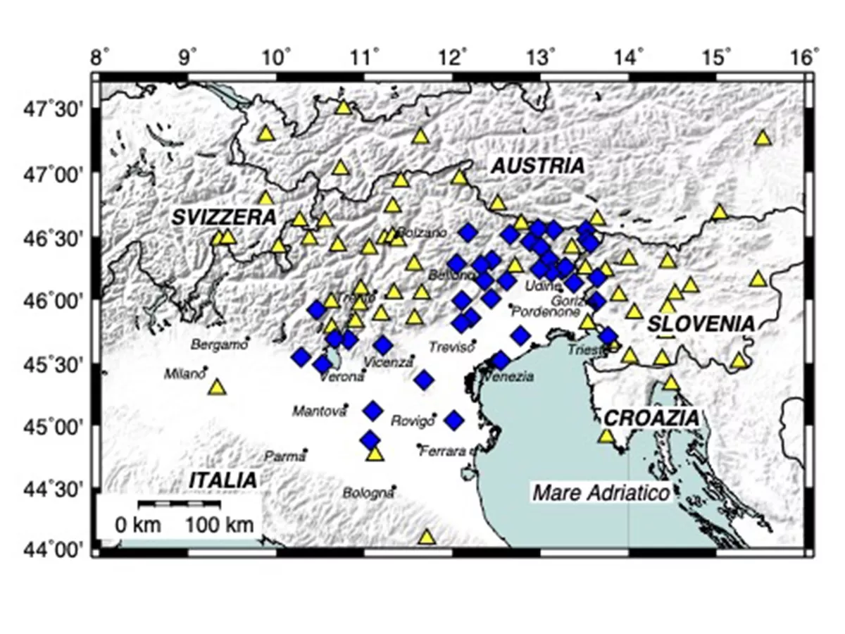
– North-East Italy Seismometer Network The North-eastern Italy Seismic Network consists of 43 stations, of which 24 broadband, 15 short-period and 4 intermediate-period. The Network is managed by OGS also on behalf of the Friuli Venezia Giulia and Veneto Regions. The stations are installed in Friuli Venezia Giulia, Veneto (in most cases), Emilia Romagna and Lombardy. The data recorded by all the stations are acquired in real time at the OGS Centre for Seismological Research in Udine. The Network also provides data to the national seismic surveillance system, with real-time data exchange with the Civil Protection Department and the National Institute of Geophysics and Volcanology (INGV). Moreover, in order to improve the quality of localizations and magnitude estimation in border regions, the Network exchanges real-time data with the seismic networks of Austria, Slovenia, Switzerland, and the Autonomous Provinces of Trento and Bolzano, and the University of Genoa. The North-eastern Italy Seismic Network is part of the CE3RN cross-border network in which also the seismic networks of Croatia, Slovakia, Hungary, Romania, Albania and Bulgaria participate. CE3RN is an example of excellence in transnational collaboration and sharing of infrastructure, data and resources. Network data is made available through OASIS, EIDA and the RTS system.
– Strong motion Network In order to guarantee the correct recording also of strong seismic events, 29 stations of the seismic network were also equipped with high quality strong motion sensors. Moreover, within the “Sentinel Buildings” projects financed by the Regional Civil Protection of the Autonomous Region of Friuli Venezia Giulia and the Interreg V-A Italy-Austria project Armonia, and the Venet-one project, other medium cost strong motion sensors (more than 100) have been installed. The network data are acquired in real time and their processing contributes to the rapid estimation of the impact of seismic events.
– Friuli Regional Deformation Network (FReDNet)
FReDNet (Friuli Regional Deformation Network) is the crustal deformation monitoring system in Friuli Venezia Giulia that the Centre for Seismological Research began developing in 2002, with the installation of the first station. In most cases the receivers have been installed in sites already hosting the sensors of the OGS seismic network. FReDNet is also part of a wider programme of geodetic survey of the Adriatic microplate that includes the repetition of episodic measurements of geodetic points. FReDNet currently comprises 19 permanent GNSS receivers (GPS+GLONASS+Galileo) for geodetic monitoring of crustal deformations in North-eastern Italy. It also provides a service for high-precision georeferenced navigation in real time according to differential correction modes (RTK – Real Time Kinematic, MRS – Multi Reference Station and VRS – Virtual Reference Station). The service is freely accessible to public, private and scientific users. The Network is integrated with the GPS network of the Friuli Venezia Giulia Region, with the National Dynamic Network of the Military Geographic Institute and with the European EUREF Permanent Network. FReDNet is included in EPOS RIDE.
Borgo Grotta Gigante, 42/c, 34010 Sgonico, Trieste
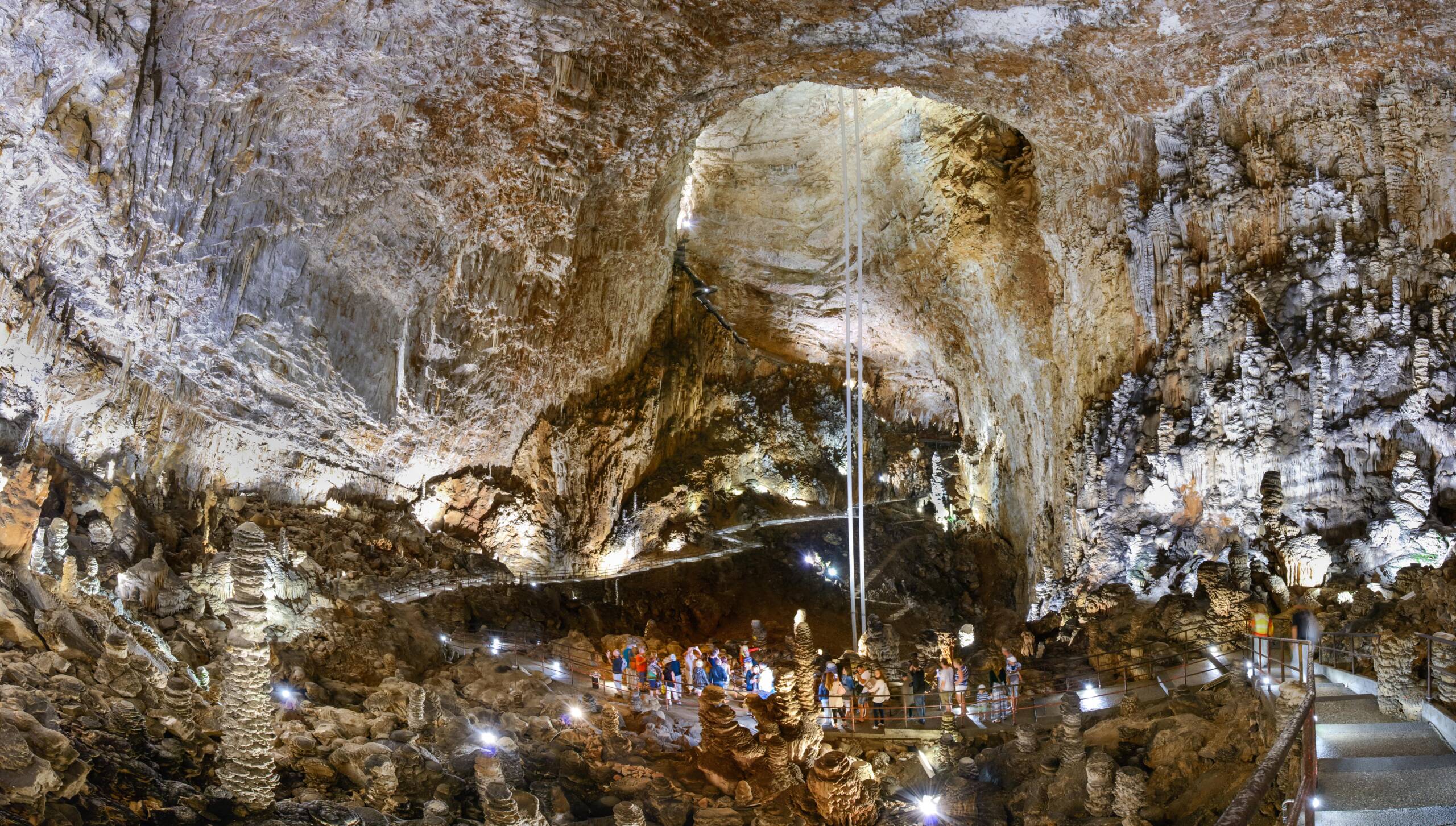
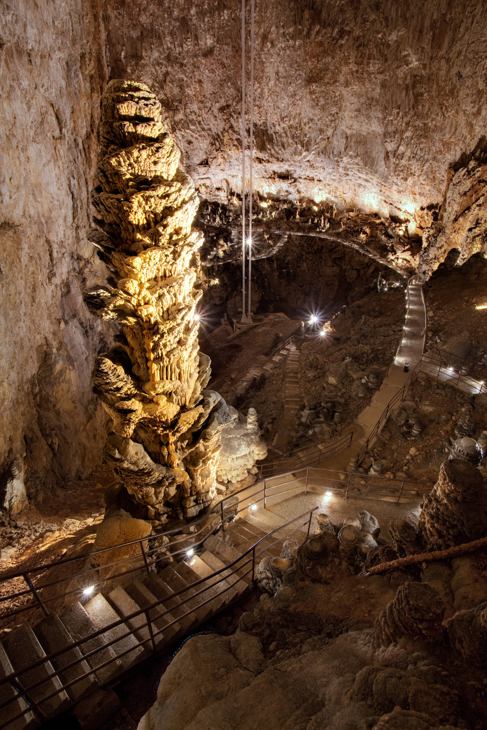
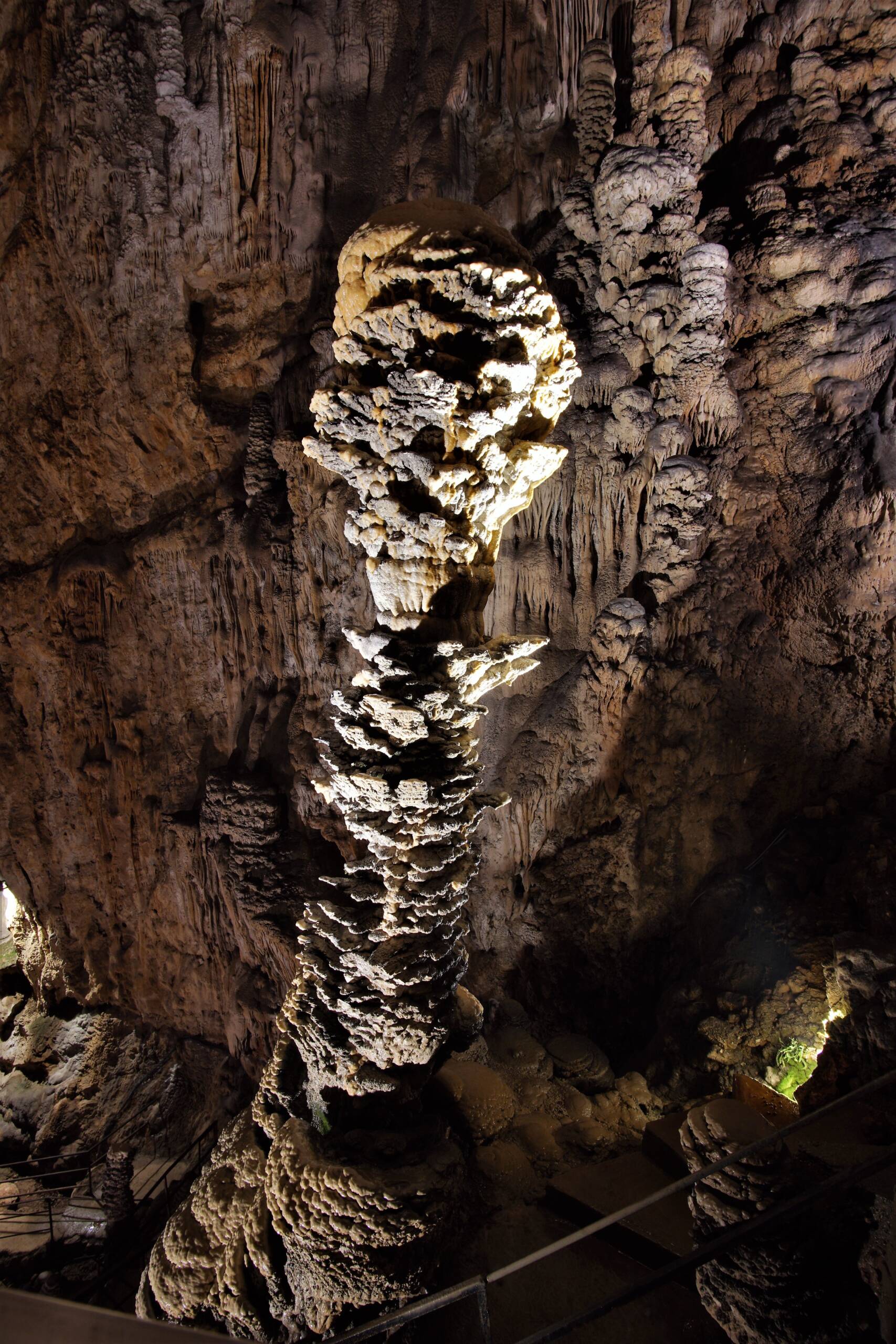
Grotta Gigante
The Grotta Gigante, the “gigantic cavern” hosting one of the world’s largest accessible single cave chambers!
Known as one of the marvels of the Karst plateau, this cave of astounding dimensions was formed between 10 and 5 million years ago deep inside the Cretaceous limestone, where the raging and turbulent waters of the Timavo river have been gnawing away at the rock giving birth to a myriad of cave systems that now riddle the entire area like holes in a gigantic block of Swiss cheese. The descent of around 500 steps, completed in 1908 during Trieste’s Austro-Hungarian era takes us down the ancient, abandoned channel through which the Timavo’s waters once rushed towards the Adriatic Sea until we reach the centre of the great cavern at a depth of 112 metres below surface. Silence now reigns in this gigantic rock dome which has become heavily colonized with stalagmites and stalactites, growing like stacks of plates or pancakes from the cave’s walls and bottom thanks to the endless infiltration and dropping of calcium-rich surface waters.
Apart from being an important regional tourist destination, the grand cavern however also hosts a most unusual underground scientific “laboratory”: The convenience of having such an enormous empty space inside the rock has allowed geophysicists to conduct studies of immense value, and it is for this very reason that several fascinating examples of geophysical instruments can be found in this special cave…and as a matter of fact, looking around the centre of this enormous subterranean dome, two long, plastic tubes that reach down almost 100 metres from the caves ceiling immediately catch the eye: they are known as geodetic pendula, and since 1959 they have been silently measuring the cave’s inclinations and thus, the slow movement of the entire Adriatic tectonic plate as it slowly shifts north eventually giving birth to the Alpine mountain ranges. The very sensitive instalment, consisting of two thin metal cables that hang from the caves ceiling onto which freely oscillating horizontal pendula are mounted, manages to capture crustal oscillations and amplify them by a rate of 40.000, using the cave’s total height of 98 metres: from slow tectonic movements to distant Earthquakes, from orbital oscillations to crustal deformations caused by the Moon’s gravity (Earth tides), from isostatic plate rebound caused by snowmelt on the Alps to regional plate deformations brought on by floodwater filling the Karst’s aquifers, these extraordinary instruments have helped to make these movements visible. The geodetic pendula, originally installed under supervision of the famous Trieste geophysicist Antonio Marussi, are owned by the University of Trieste while research is conducted by the OGS (Institute for Oceanography and experimental Geophysics), which also operates three wideband digital Streckeisen-type Seismometers in the cave. Other types of research that is undertaken include measurements of cave temperature, CO2 concentration and radon gas emissions from the rock as well as studies of cave Flora and Fauna.
The guided tour of Grotta Gigante takes about one hour, in which 500 steps (112 vertical metres) are taken to reach the bottom followed by 500 steps on foot back to the surface. The panoramic staircase on the way out allows for multiple stops to catch breath and take photographs as well as admiring the cave from almost every angle. Since the caves temperature lies around 11 degrees Celsius it is advisable to cover up with a thin jacket or jumper, and a pair of comfortable trainers or walking shoes with rubber sole are strongly recommended!